
Writer Gets Her Kicks On Route 66: Part 10
Trending
Editor's Note: This is the 10th column in a series featuring the author's travels along Route 66.
This trip on Route 66 was my comeback to the numerous ocean cruises my husband has taken us on in the last few years. He loves cruising on water. I love cruising the back roads of America. It almost seems like it should be the other way around, doesn't it?
After driving along a curvy mountain road without guardrails, Oatman, Arizona, came into view. Oatman is another former gold mining town, a fun tourist stop with staged gunfights in the streets. The biggest attraction isn't the gunfights or the old buildings that house souvenir shops and restaurants. People come from miles around, in fact from all over the world, to see the burros that freely roam the streets. They are descendants of burros that once worked at the mines and either got loose or were set free. Today's animals appear tame as they bump and push into the bags carried by tourists, hoping to get a snack. Signs indicating otherwise, say the burros are wild and will bite and kick.
As we went in and out of shops off the boarded walkway while trying to avoid the begging four-legged animals, I met Sultana Hall, who has co-owned "Outlaw Willie's" for 25 years.
"We get people from all over the world. Today, we had France, Denmark, Italy, Norway, Germany, Mexico and Switzerland. Most of them know more about Route 66 than we do. In 25 years it's changed a lot. We'd be lucky if we'd see five people in a day. At the height of tourism we had 750,000 and now 400,000-500,000, because of terrorism. A lot of international travelers don't want to fly."
"The main reason people come here is Route 66 and our burros. The original ones were left behind by gold miners," she said. "Burros can find water, where horses can't. There are about a dozen, which is where they like to keep the herd. A short while ago, we had 26, but that's too many. They fight. The Bureau of Land Management adopts them out to good homes. People want them because they are used to people."
"Hay tubes are sold now for a dollar. They used to sell carrots, but with so many people feeding them, it was not good for the burros."
"We love it here. It is fun meeting all of these people every day. We have made friends over the years."
As we drove away from Oatman, the location of the filming of the 1962 movie "How the West Was Won," we soon came to see another change in terrain. The number of terrain changes has fascinated us on this trip. Here were black rocky spines lining the foothills.
I found it interesting that, unlike our towns when you drive through them there is a distinct feeling you are in a town, but small towns on the desert appear to have had a bunch of houses dropped out of the sky. The reason for this could be the lack of grassy areas to set the boundaries.
We soon crossed the Colorado River at the California state line. The first thing we expected and witnessed after crossing into California was the rise in gas prices. On the Arizona side they were $2.08, whereas California came in at $3.24-3.79.
Continuing our way across the Mojave Desert on the Main Street of America, in and out of small towns, we saw what is left of cafes, gas stations and motels, also homes, small schools, all forgotten after I-40 pulled the traffic away. We saw a banked berm on which hundreds of people had placed stones spelling out their names. Some may have been memorials to friends and/or family. A tree with many hanging shoes was in the same area, near Amboy, a town where there is nothing more than nine houses and a cafe with a gas pump reading $4.99 for unleaded gasoline and $5.39 for premium.The Amboy Crater, the cinder cone of a volcano that last erupted about 10,000 years ago, was just west of here. It was designated a U.S. Natural Landmark in 1973.
We rolled into Ludlow after dusk. There was a cafe and motel on one side of the road and a convenience store on the other. The cafe was closed for the day. A sign at the motel directed travelers who were looking for lodging to the convenience store. We spent the night after looking at one of the modest rooms with one of us posting our location on Facebook in case we were never heard from again.
After surviving the night, we found an interesting sign outside of the Ludlow Cafe. "In 1957 California's Lawrence Livermore Laboratory launched an experimental program called Operation Plowshare to use nuclear energy for such applications as power plants, medicine, mining, the extraction of oil and natural gas, and for excavation of canals, harbors and roadways. Under Plowshare, a 1963 feasibility study was conducted for Project Carryall, a plan to realign the Atchison, Topeka and Santa Fe Railroad and provide a route for Interstate 40. Twenty-three nuclear explosions totaling 1.8 megatons were to be used to excavate a 2-mile cut up to 350 feet deep through the Bristol Mountains east of Ludlow and remove 60-million-cubic-yards of rock. Despite many assurances from the Atomic Energy Commission, obvious environmental and health concerns over this and other Plowshare projects caused several postponements, and in 1968 the project was dropped completely. Twenty-eight nuclear tests were conducted under Operation Plowshare before its termination in 1975."
After breakfast, we passed lava fields lining both sides of the road between Ludlow and Newberry Springs.
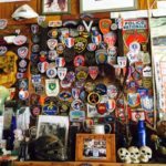
The Bagdad Cafe and its defunct motel, which was the sight of the filming of a movie by the same name, was our next stop in Newberry Springs.
"We can see five or six buses in a day," said employee George Mahar.
Signed currency from all over the world hangs on one wall. Business cards are tacked up on another. Autographed photos of celebrities, including one of Celine Dion, are interspersed throughout the rooms. Famous soccer and rugby players from England and France have left pennants. These, along with flags and T-shirts representing motorcycle groups are attached to the ceiling. Patches from every branch of law enforcement in France have been received and many other countries are represented. Decals fill a glass display case in another area of the room.
Returning tourists look for the signatures they left in one of 51 guest registry books.
Twenty miles up the road, west of Daggett, we are diverted to I-40 because the Barstow Marine Corps Logistics Base has been built across old 66. The EZ 66 Guide points out "Barstow, California owes its existence to the railroads. In fact, the current location of downtown was dictated by the Santa Fe in 1925, when the whole town had to be moved to current Main Street, so railroad yards could be expanded. Left behind, north of the railroad yards, was the 1910-era Casa Del Desierto, a former Harvey House."
After getting an education about Harvey House from our niece's friend during our visit to Phoenix, we decided to stop to check out the Harvey House in Barstow. We learned it was built in 1911 (You were close Jerry McClanahan.) by Fred Harvey. Each was named, most with Spanish names and most built by a Spanish architect. Most put cots everywhere for the railroad workers and the troops. Troops got off, would stay the night and continue in the morning. The kitchens stayed open later, because the dining cars were owned by Fred Harvey and when the trains stopped, they would restock the dining cars.
The cause of this Harvey house to close was WWII. The hotel closed in 1957 and the kitchen in 1972. After several years of shuttering, renovations were started in 1999, $8.3 million has been spent to date. It is now used as an Amtrak station servicing two trains per day. Two museums, a Route 66 museum and a railroad museum, are on the first floor. Banquets and receptions are held in two ball rooms with offices on the second floor.
I found it interesting that this location had burned down three times and was originally built in approximately 1889. It completely burned two months after completion due to a fire caused by a railroad spark. There was nothing located in the area and once it was realized it was going to burn, the fire was let go. The second fire happened two years after the next building was finished and the third fire occurred eight years after rebuilding. Finally, the fourth building was built with brick, unlike the previous wood structures. One can see this two ways- perseverance or slow learners.
To be continued …