After Wild Weekend, Harsh Weather Continues Today
-
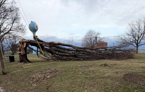
- A tree is down in Memorial Park after 70 mph winds on Sunday night. Photo by Braden Carmen
-
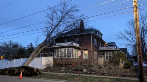
- A tree hit a home in Fredonia on Barker Street.
-

- First responders are pictured outside a building on East Second Street after its roof was partially ripped off by high winds Sunday. The sidewalk remains closed outside the building Monday. P-J photo by John Whittaker
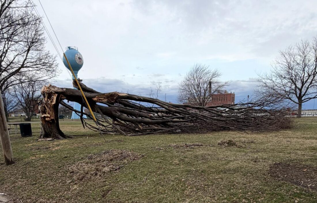
A tree is down in Memorial Park after 70 mph winds on Sunday night. Photo by Braden Carmen
More than 2,700 people remained without power in Chautauqua County on Monday afternoon with another round of wind hitting the area Monday night and into today.
As of 7 a.m. Monday, National Grid crews remained in the field completing repairs related to strong winds this weekend that affected more than 27,000 customers, with preparations underway for a second, potentially more damaging wind event.
There were scattered outages in Chautauqua County on Monday. Areas near the Lake Erie shoreline in the north county were particularly hard hit, though the Frewsburg and Kiantone area were hit hard over the weekend with hundreds without power for stretches of Saturday and Sunday. Frewsburg Central School was on a two-hour delay Monday due to power outages throughout the Frewsburg area. In total, National Grid’s outage map showed 3,065 customers affected as of about 11 a.m. Monday. That number was down to 2,784 around 1 p.m.
A portion of Second Street was closed from Prendergast Avenue to Foote Avenue as well as Prendergast Avenue from Third to Second streets due to a roof that blew off a building during Sunday’s wind storm. The streets reopened around 10:30 p.m. Sunday, though the sidewalks around the area remain closed.
National Grid officials said the company has secured external resources to support potential power restoration efforts. The company also has activated its comprehensive emergency response plan, including:

A tree hit a home in Fredonia on Barker Street.
– Mobilizing internal line, field and tree crews, and securing external resources.
– Pre-staging crews, equipment, and materials in areas anticipated to be most severely impacted.
– Proactively reaching out to elected, municipal and emergency management officials to keep them updated on our preparations and provide safety information.
– Reaching out directly to customers through traditional and social media channels, email and texts, and on our website to provide safety information and to urge them to be prepared.
– Conducting outbound calls to life support and critical facility customers to ensure they are prepared.

First responders are pictured outside a building on East Second Street after its roof was partially ripped off by high winds Sunday. The sidewalk remains closed outside the building Monday. P-J photo by John Whittaker
“Some of our most volatile storms happen during this time of year, as we alternate between the remnants of winter and the advance of warmer spring-like weather,” said Tom Gozelski, National Grid New York’s Lead Director of Electric Operations, said Sunday afternoon. “Having one severe weather event immediately follow another is not ideal, but our crews are ready to restore service quickly and safely should we experience outages. I want to thank our communities and their leaders for their patience and cooperation this weekend, and ask for them to keep our field force in mind as we prepare to respond over the next few days.”
On Tuesday, forecasters are calling for lake effect snow and areas of blowing snow. Additional accumulations of between 1 to 3 inches are possible in the most persistent snows. Winds between 15 and 30 miles an hour continue Tuesday with gusts up to 45 miles an hour. Highs Tuesday are in the mid 20s. Tuesday evening lows are expected to be between 15 and 20, with winds early in the evening between 10 to 15 miles an hour and gusts up to 30 miles an hour. Eventually the wind is expected to lighten later Tuesday night.
Winds are lighter Wednesday, though highs are expected to be in the mid 30s.
Top stories

Falconer, Kennedy Firefighters Extinguish Elmwood Avenue Fire
Democrats Seek Tougher Price-Gouging Penalties
After Wild Weekend, Harsh Weather Continues Today

Frewsburg School Cutting Positions To Balance Budget

Retired Actor From Warren County Shares Hollywood Stories