Leveling Up: NASA Program Brings Gauges To County Lakes

A new lake gauge from the Lake Observations by Citizen Scientists and Satellites program was added to the Prendergast Point boat launch on Chautauqua Lake on June 6. Submitted photo
If you spent any time walking around the public boat launches of Chautauqua Lake, Cassadaga Lake, or Bear Lake this summer you might have noticed something new and unexpected sticking out of the water.
This happened to me, and as it turns out, there is an interesting story to be told.
In late June I happened to stop at the Prendergast Point boat ramp on the way to Chautauqua Institution, where I saw that a new lake level gauge had been placed in shallow water off to the right side of the launch. The gauge was labeled ‘LOCSS’, Lake Observations by Citizen Scientists and Satellites. I said to myself, “That’s interesting, I wonder what this is all about?” As it turns out, these three county lakes are now a part of a global network of monitoring stations that are helping scientists learn more about Earth’s waterways.
It took some time for me to wrap my head around the vast scale of this project. After first seeing the gauge, I asked around to a few people about LOCSS. No one seemed to know much. From there I made my way to locss.org, where it explained that “We are working with a network of citizen scientists who are reporting lake height by reading simple lake gauges. We combine these measurements with surface area measurements of the lake derived from satellite images. By knowing the changes in both lake height and lake surface area, researchers can understand how the volume of water in a given lake is changing over time.” The LOCSS page goes on to explain that the work is a NASA-funded project in collaboration with the Department of Geological Sciences at UNC-Chapel Hill, the UNC Institute for the Environment’s Center for Public Engagement with Science, University of Washington Department of Civil and Environmental Engineering, and Tennessee Technological University Department of Computer Science.
Over time, I learned more about the scope and objectives of the LOCSS project, and how these gauges made their way to our local lakes. Dr. Mike Jabot, State University at Fredonia professor of science education, has helped to bring Chautauqua County’s waterways into the fold of this massive undertaking.
“I got involved with the research team out of North Carolina,” Jabot said. “I think it is a pretty cool scheme to engage citizens and communities.” Jabot aided site selection for the county’s three new gauges, and continues to work with LOCSS to record readings. “They want readings all the time. I go out when there are satellite flyovers,” Jabot said. “There is a code on the sign on the gauge and you text the reading on the gauge off of that code.”
All told, 11 New York State lakes were added to the network this summer, bringing the state’s total gauges to 15. Since the project was started in 2017, tens of thousands of lake measurements have been recorded by LOCSS citizen scientists across North America, as well as in France, Chile, India, Nepal, Bangladesh, and Pakistan. These hundreds of gauges and their most up-to-date measurements can be seen at locss.org/view-lake-data.
The data gathered by LOCSS really begins to shine when it is combined with satellite measurements. When researchers have accurate measurements of water level changes as well as precise surface area data, they can begin to understand how bodies of freshwater are changing over time. As fate would have it, this relationship between advanced satellite imagery and on-the-ground monitoring is scheduled to take an exciting step forward on December 5, 2022. That is the planned launch date for the Surface Water and Ocean Topography satellite, a joint venture between NASA and France’s National Centre for Space Studies. SWOT’s mission aims to provide researchers with global measurements of freshwater lakes and oceans to better understand weather and climate, supplies of freshwater, flood modeling, and current dynamics. LOCSS notes that many of its lake gauges are in a unique position to help validate the measurements generated by this new satellite mission.
“I have my fingers crossed for the December launch, it’s very exciting,” Jabot said. “This is the first time we will have a sensor with this capability.”
As local stakeholders we spend a lot of time focused on challenges and problems that are, well, local. There is good reason for this, but it can also be helpful to hit the ‘zoom out’ button on our perspective. It’s not every day that you realize your local lakes are part of a global scientific effort to understand the natural world using the most modern satellites ever designed. That’s pretty cool. Monitoring lake levels is not new. The United States Geological Survey and the county are partners on a gauge in Bemus Point that has been in operation since 1972. What is new, and something to get excited about, is the inclusion of our lakes into a worldwide initiative. If you want to submit an observation to LOCSS for any of the participating waterbodies you can follow the instructions on the gauge itself or visit www.locss.org/region/new-york.
Local News
South and Center Sewer District to raise rates
For the first time in 25 years, residents who live in the South and Center Sewer District will be having to pay ...
New comptroller wades into Dunkirk fiscal woes
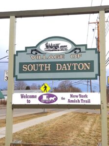
South Dayton voters reject dissolving village
‘Speaking For My Peers’
Panama looks to reinforce garbage can requirements
YWCA to honor 2026 Women of Achievement
The YWCA Jamestown will honor its 2026 Women of Achievement - Leishya Rios Pérez, Makayla Santiago-Froebel, Briana ...