Officials Working To Stabilize Riverfront Shoreline
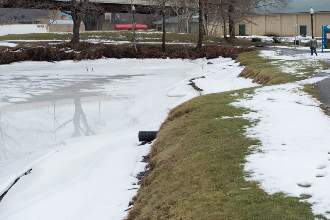
A view of the eroding Chadakoin River southside shoreline near the Greater Jamestown Riverwalk. Local officials are working to stabilize the shoreline. Submitted photo
The shoreline on the southside of the Chadakoin River is crumbling into the water near the Greater Jamestown Riverwalk.
Local officials have received more than $400,000 in county and state grants to attempt to stop the shoreline erosion. Earlier this week, the Jamestown Riverfront Management Council discussed the project to stabilize the shoreline.
Twan Leenders, Roger Tory Peterson Institute of Natural History president, said project leaders have met with engineers, with 70 percent of the stabilization project concept drawings being completed. He said they will soon start the permit process with the state Department of Environmental Conservation for the project.
Following the meeting, Leenders told The Post-Journal they’ve received two grants for around $40,000 from the county’s 2 percent occupancy tax fund and they received a $314,000 state grant for the project.
“The bank it is just crumbling. It just falls into the water. It has been happening for a long time. A part of the Riverwalk path has been undercut by the crumbling,” he said. “The idea is to not just rebuild the bank, but to rebuild it better. The recent state grant is icing on the cake. We will be able to involve additional infrastructure, storm water management features and we will also have a significant education component.”
Leenders said they received the first county grant a couple years ago, but they didn’t want to start the project before heavy machinery installed the pedestrian bridges along the riverfront, which was done last summer.
Leenders said they are hoping to start the project this spring. He said they will need a special permit from the DEC in order to do the project between April 1 and June 30. He added, during this time period, there a construction lockout around the river for fish spawning season. Leenders said the project won’t interfere with any species the lockout is meant to protect because these types of fishes don’t habitat where the shoreline stabilization project will be done.
Leenders said the project will stabilize approximately 1,000 feet of streambank, upstream from Warner Dam. In its current state, runoff from approximately 10 acres of impermeable surface and cropped lawn is allowed to enter the river unobstructed. This sheet-level flow is causing the river banks to erode, resulting in significant sediment loading to the Chadakoin River.
The proposed project will take place on a city-owned land that is part of the Riverwalk. State DEC hydrologic and habitat management catalogue was used to determine the stabilization techniques for the project, which includes an infiltration basin, infiltration trenches, critical area plantings, filter strips, public education, urban forestry and porous pavement. Using the guide, streambank stabilization and biotechnical, or living shoreline, methods will be used to stabilize the eroded streambank.
Leenders said with guidance from Roger Tory Peterson Institute of Natural History conservation staff, a living shoreline buffer will eliminate the existing sheet-level runoff and bank erosion problems. Permeable pavement will be incorporated along the Riverwalk path, with infiltration trenches redirecting flow from the paved surfaces of the BPU parking lots to the infiltration basin.
Soil & Water Conservation District officials have drafted structural stabilization designs and will submit them for the required permits, Leenders said. He said education opportunities will be ongoing throughout the process, which will be facilitated by Roger Tory Peterson Institute.
Local News

State rep visits Westfield for conversation
Aspire acquires former WCA Home

They’re Back: Jackals Return To Area For Clinic

Seneca Casino To Host Kansas, Deep Purple Tour Date

Superlative Support: WCA Foundation Makes Largest Allocation In Its History To UPMC Chautauqua
Grange history focus of Thursday program in Westfield
WESTFIELD — The history of the National Grange, with a focus on the organization’s first working grange in ...