What To Know About When We Get So Much Snow
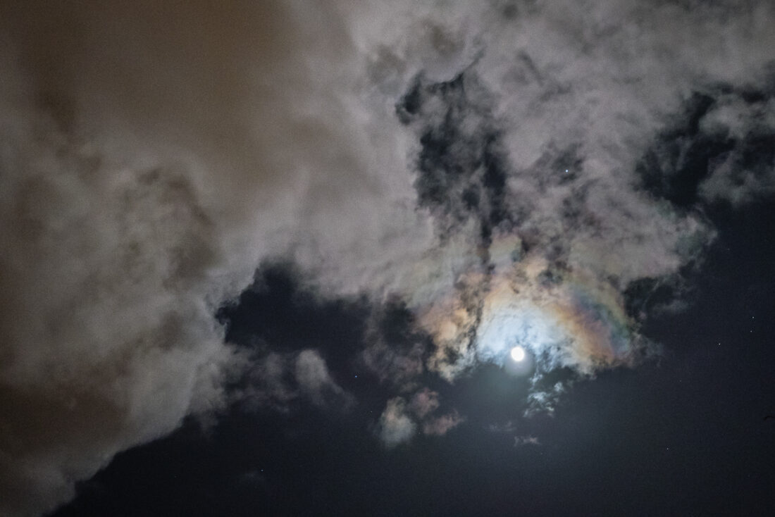
A moonbow photographed as storm clouds roll in. Photo by Jeroen Hermkens
Weather is more than just a colorful chart on your television screen or crossing your fingers for a snow day. Winter comes with temperature drops, bird migration, and bundling up. Here, winter also comes with plenty of shoveling and making sure your home stays warm and insulated. As we trudge through thick white powder to dig out our vehicles, we find ourselves asking, “Why does Western New York get so much snow?”
It all begins in the troposphere. That snowflake you caught on your tongue as a child travelled an hour from the sky to land on you. Anywhere from 4 – 12 miles above us, constantly moving and shifting, the air travelling from as far north as Alberta, Canada, has an effect on the snow we see here. From time to time, meteorologists will speak of an “Alberta Clipper” which is known for bringing cold fronts and arctic blasts to our region. These clipper systems get caught in a southern-moving jet stream, which are narrow bands of wind that carry temperature and precipitation along with it.
Jet streams are responsible for pushing air (and weather) into different parts of the country. A jet stream not only brings wind and weather, but also has the potential to build cold fronts and warm fronts as it travels around the planet. This is how temperatures change from day to day, carried through the atmosphere to provide us with a warmer winter day or a frigid winter night. From the moment cold air hits the coast of Lake Erie, we are right in the path for a complete change in weather.
We have all heard of the term ‘lake effect snow,’ especially being a part of the region where one of the great lakes, Lake Erie, has an influence on how winters pan out in Western New York. This large body of water gives us unique weather patterns. With our geographic positioning being so close to the Canadian Arctic, cold air is brought down when the jet stream dips south towards us, bringing winter weather when it travels over Lake Erie. When the lake’s waters are warmer than the air above, water particles rise and form into clouds. The further upward they travel, water droplets begin to freeze, turning into snow.
A combination of conditions are responsible for the amount of snow we see throughout a winter season, including the barometric pressure in the air. This measurement is the driving force for high- and low-pressure systems. Low-pressure jet streams carry storms and dramatic drops in temperature, which can lead to bomb cyclones in the winter. These cyclones are the result of low-pressure systems entering the area and are known to make temperatures drop as much as 20+ degrees overnight. Alternatively, high-pressure systems are more stable, bringing clear skies and predictable weather with them.
Although brief, snow squalls are intense periods of snow and appear as long narrow bands on a radar system which is used to track weather. Snow squalls are known to dump up to 2 – 3 inches of snow on the ground per hour. These squalls cause sudden white-out conditions and blizzard winds, often just miles apart. Meteorologists use complex formulas derived from thermodynamics to predict how water, air pressure, and temperature will interact with one another. Lake effect snow is notoriously known as being hard to predict given its quick-acting systems and the potentional for fast-moving snow squalls.
Having the opportunity to live so close to Lake Erie and experiencing lake effect snow also gives us a glimpse into some rare weather phenomena. One known as ‘thundersnow,’ is just as it seems. During intense winter storms such as the bomb cyclone, some listeners can hear thunder, just as we would during a storm in summer. Thundersnow is not as loud as heard in the summer, since snow acts as an insulator and can muffle sounds.
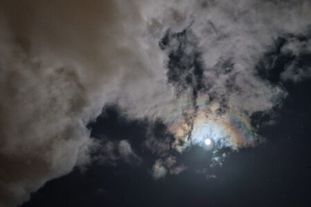
Another winter weather phenomenon we can experience in our area is known as a ‘moonbow,’ which occurs during a full moon the night before a storm. Ice and snow crystals in the atmosphere reflect from moonlight, creating a dim rainbow around our celestial neighbor in clear skies. These snow and ice crystals are waiting in the troposphere, ready to fall upon us within hours.
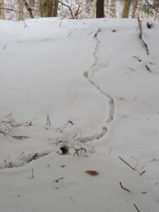
Next time you decide to embark on a winter adventure in the forest after a snow storm, pay close attention to what side the snow piles up on a tree. This tells us which direction the snow was coming from. The circular trunk of a tree blocks the other side where the wind and snow won’t hit, so it only builds up on one side where wind is blowing and dropping snow along with it. Clues such as this help us understand where jet streams are coming from and where they are headed next.
As all life slows down in winter, take a few moments to ponder on the complexities of what makes snow and why we have so much of it in Western New York. There is much more happening in the atmosphere than just clouds passing by.
Audubon Community Nature Center builds and nurtures connections between people and nature. ACNC is located just east of Route 62 between Warren and Jamestown. The trails are open from dawn to dusk and birds of prey can be viewed anytime the trails are open. The Nature Center is open from 10 a.m. until 4:30 p.m. daily except Sunday when it opens at 1 p.m. More information can be found online at auduboncnc.org or by calling 716-569-2345.
Nature
Bryophyta And No Rolling Stone
Staying Warm During A Cold Winter
What To Know About When We Get So Much Snow
The Secret World Beneath The Snow
There Is Life Beneath The Snow
Winter Exposes Troubled Trees, Bark
The seasons are changing from fall to winter, and one of the major changes to the environment is that the deciduous ...