Land Use And Forest Trends Point To Declining Water Quality
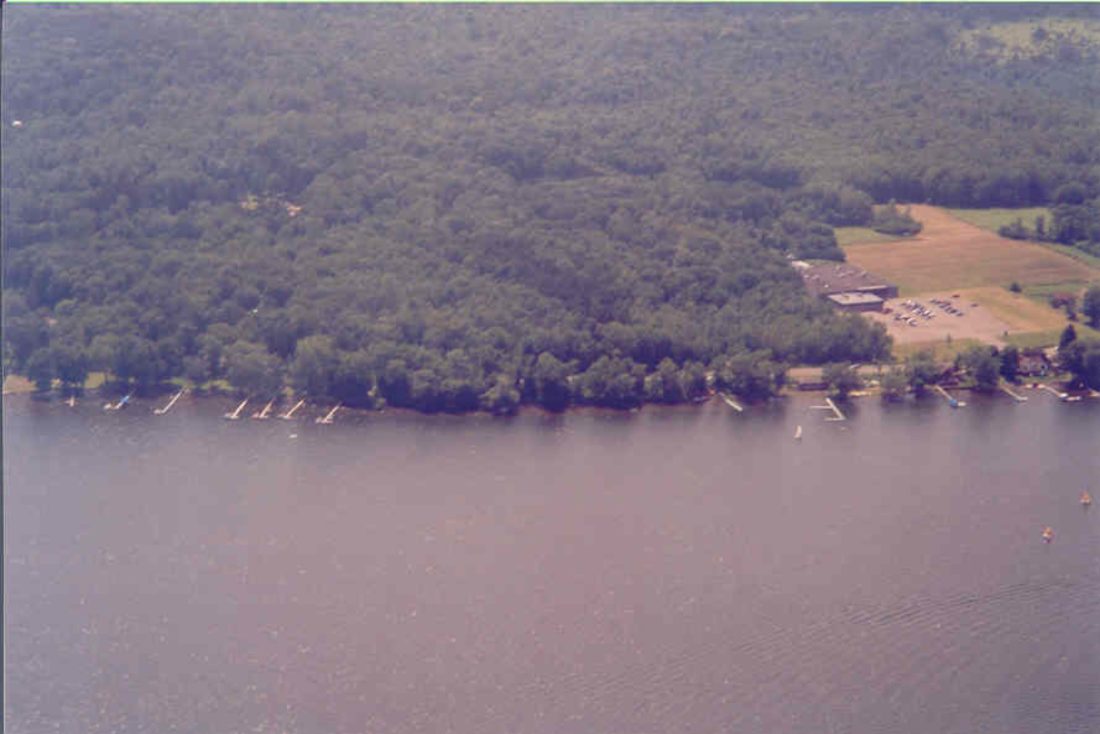
This forested area near Mayville helps deliver clean water to Chautauqua Lake. Photo by CWC
Approximately 8,000 part-time and permanent residents depend upon Chautauqua Lake water for drinking and domestic use. Chautauqua Lake is a public drinking water source for Chautauqua Institution and the Town of Chautauqua Heights Water District. It is also incidental drinking water to thousands of children and adults who play, swim or water ski in the lake each year.
Protecting the Source, a publication by the Trust for Public Land and American Water Works Association, states that “Watershed protection is the first and most fundamental step in a multiple-barrier approach to protecting drinking water. Healthy, functioning watersheds naturally filter pollutants and moderate water quantity by slowing surface runoff and increasing the infiltration of water into the soil. The result is less flooding and soil erosion, cleaner water downstream and greater groundwater reserves.”
In 2009, I participated in the development of the Chautauqua Lake Watershed Management Plan. Project consultants Bergman Associates provided information that forest cover in the watershed had decreased by 1.4 percent between 1992 and 2001 and that core forest areas had also declined in size. Forest cover is one of the most important indicators of watershed health. Each tree in a watershed is a self-contained water filtration unit, performing the functions of absorbing the energy of raindrops with branches and foliage, holding the soil intact with its roots and absorbing nutrients that otherwise could contribute to downstream lake aquatic plant and algae growth. The soil floor of a healthy forest is held together with a tangled matrix of woody and herbaceous tree roots. In small headwater streams, where this matrix is part of the stream bed, it is able to actually filter pollutants. The floor of an old forest is an uneven surface, with nooks and crannies and pits and mounds that trap water and allow it to slowly seep into the ground. With this healthy forest topography, it takes a heavy rainfall to overtop these pits and obstructions to create any significant runoff. In an ideal forest watershed system, groundwater is recharged, streams are fed with spring water throughout the year and precipitation is intercepted by foliage, leaf litter and uneven ground. The more our watershed is covered with healthy forests, the cleaner the water is in the receiving body of water – the lake.
This is borne out in the cost of producing drinking water. There is a direct, inversely proportional link between the percent of forest cover in a drinking water watershed and the cost of treating water for public consumption. According to a study in 2002 by the TPL and AWWA, for every 10% increase in watershed forest cover, water treatment costs declined by 20 percent. Another study showed that for every 4 percent increase in source water turbidity (suspended clay, algae, etc.), treatment costs increase by 1 percent. Additional information indicates that water quality approaches its optimal between 70 and 100 percent forest cover.
What does this mean for Chautauqua Lake? Based on information presented to the Plan Advisory Committee, forests cover only 56 percent of the Chautauqua Lake watershed – below the 70 percent or more optimal level. And many sub-watersheds fall far below that. If we want to arrest future declines in lake conditions, we have a lot of conservation work to do! Although our local population declined between 1971 and 1994 (data cited by Bergman), scattered residential and commercial development consumed twice as much land in the watershed. “Small development” is seen as a “very high threat” to Chautauqua Lake according to the Upper Allegheny River Basin Conservation Action Plan (The Nature Conservancy, 2008). Large blocks of forest are being cut up into ever smaller pieces due to residential and recreational construction and hobby farms. Very visible recent ongoing conversions of forest-to-residential development can be seen along many roads in the watershed. The loss of forest filtration functions is compounded by excessive runoff from rooftops, paved surfaces and compacted residential lawns, all of which contribute to flooding, excessive stream erosion and sedimentation in the lake, and which create fertile conditions for excessive plant growth. The implications are not good for future conditions in Chautauqua Lake. However, the CWC, landowners, organizations and government can work together to design and implement effective land conservation, mandatory stream buffer, zoning and reforestation efforts to conserve and restore substantial acreages of healthy forests. CWC encourages all to get on board for watershed forest land conservation! Otherwise, we can expect lake conditions to decline over coming decades.
Additional sources of information: Conserving Forests to Protect Water: www.slcdocs.com; Protecting the Source, Trust for Public Land: www.tpl.org; Working Trees for Water Quality: digitalcommons.unl.edu.
The Chautauqua Watershed Conservancy is a local not-for-profit organization that is dedicated to preserving and enhancing the water quality, scenic beauty and ecological health of the lakes, streams, wetlands and watersheds of the Chautauqua region. For more information, call 664-2166 or visit www.chautauquawatershed.org or www.facebook.com/chautauquawatershed.
Nature
Bryophyta And No Rolling Stone

Staying Warm During A Cold Winter

What To Know About When We Get So Much Snow

The Secret World Beneath The Snow
There Is Life Beneath The Snow
Winter Exposes Troubled Trees, Bark
The seasons are changing from fall to winter, and one of the major changes to the environment is that the deciduous ...